Trail  Gemeinde Neustift im Stubaital - 2023-07-12_17h13m25_Le_Lac_de_Mutterberger__Mutterbergersee_ - Photo

2023-07-12_17h13m25_Le_Lac_de_Mutterberger__Mutterbergersee_

© OpenStreetMap contributors
Length
Length
9.7 km
Max alt
Max alt
2481 m
Uphill gradient
Uphill gradient
801 m
Km-Effort
Km-Effort  
20 km
Min alt
Min alt
1704 m
Downhill gradient
Downhill gradient
801 m
Boucle
Boucle
Yes
Creation date :
2023-07-12 15:13:25.762
Updated on :
2023-07-12 15:13:26.788

(0 Reviews)


Scan this QR Code to open this trail in the SityTrail application

FREE GPS app for hiking

Logo SityTrail SityTrail

IGN / Geographical institutes

Download SityTrail from the App Store Download SityTrail from Google Play

Logo SityTrail SityTrail World

The world is yours!

Download SityTrail from the App Store Download SityTrail from Google Play Download SityTrail on Huawei AppGallery

About

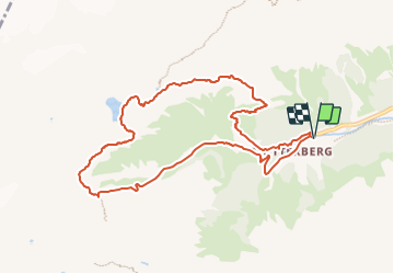
Trail of 9.7 km to be discovered at Tyrol, Bezirk Innsbruck-Land, Gemeinde Neustift im Stubaital. This trail is proposed by Christine Torfs.

Elevation profile

Positioning

Country:
Austria
Region :
Tyrol
Department/Province :
Bezirk Innsbruck-Land
Municipality :
Gemeinde Neustift im Stubaital
Location:
Unknown
Start:(UTM)
664152 ; 5208888 (32T) N.

Trails nearby

Trail On foot Gemeinde Neustift im Stubaital - Wilde Wasser Weg - Photo
On foot
PRO

On foot

Easy
Gemeinde Neustift im Stubaital, Tyrol, Bezirk Innsbruck-Land, Austria
3.5 km | 8.9 km-effort
2h 0min
No
Trail Walking Gemeinde Neustift im Stubaital - Wildwasserweg Stubaital - Photo
Walking
FPFSB

Walking

Difficult
Gemeinde Neustift im Stubaital, Tyrol, Bezirk Innsbruck-Land, Austria
9.2 km | 12.8 km-effort
3h 40min
Yes
Trail Walking Gemeinde Neustift im Stubaital - wilder Wasserweg 2019 - Photo
Walking
ErwinMueller

Walking

Very easy
Gemeinde Neustift im Stubaital, Tyrol, Bezirk Innsbruck-Land, Austria
7.7 km | 12 km-effort
3h 2min
No


Close
My subscriptions